

-
Old maps of Malta
Malta 2005.01.19
In issue: Stamp(s): 4
Printing: lithography
Issued in: mini-sheets of 10 (2*5) stamps
-
Number by catalogue: Michel: 1371 Yvert: 1336 Scott: 1190
Perforation type: 14x14 ½
Subject:
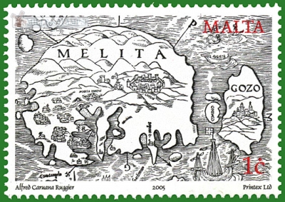
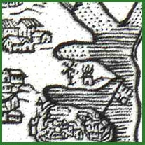
1 cent. Map by Abbe Jean Quintinus, 1536
Additional:
*What is known as the Quintinus map is represented on the 1c stamp, courtesy of the Gozo National Library. This was the first printed map of the Maltese Islands accompanying the first printed description of Malta written by Abbe' Jean Quintin, and published in Lyon by Sebastian Gryphus. This map served as a model for several later maps, including one by Giacomo Gastaldi, and a series of siege maps by the Palombis in 1565, all of which are of the circular type.
Topics: Mills in Art Windmills
-
Number by catalogue: Michel: 1374 Yvert: 1339 Scott: 1193
Perforation type: 14x14 ¼
Subject:
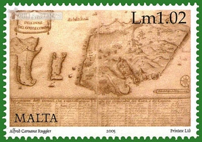
1 pound and 2 cents. Map of maltese islands, by Fr. Luigi Bartolo, 1745
At least 3 windmills on the map it is possible to see.
Additional:
*The stamp shows a map of Gozo, with Comino, Cominotto and the Marfa peninsula on Malta, courtesy of the National Library, Malta. It is a pen drawing by Padre Luigi Bartolo, a Maltese Capuchin scholar. This map is orientated with the south-west to the top, as the convention that north should always be at the top had not yet come into being. The eight columns along the foot contain the key to 79 place-names.
Topics: Mills in Art Windmills

-
Africa
- Algeria ⁄ 2
- Ascension Island ⁄ 1
- Cameroon ⁄ 1
- Cape Verde ⁄ 2
- Central African Republic ⁄ 1
- Ciskei ⁄ 1
- Cote d'Ivoire ⁄ 1
- Egypt ⁄ 1
- Equatorial Guinea ⁄ 1
- Ethiopia ⁄ 1
- Fernando Pó ⁄ 1
- Gambia, The ⁄ 1
- Ghana ⁄ 3
- Lesotho ⁄ 2
- Liberia ⁄ 1
- Mauritius ⁄ 1
- Mayotte ⁄ 1
- Morocco ⁄ 8
- Namibia ⁄ 2
- Niger ⁄ 1
- Reunion ⁄ 1
- Rhodesia ⁄ 1
- Senegal ⁄ 1
- Seychelles ⁄ 1
- Somalia ⁄ 1
- South Africa ⁄ 7
- South West Africa, SWA ⁄ 1
- Southern Rhodesia ⁄ 1
- Spanish Sahara ⁄ 1
- Tanzania ⁄ 2
- Transkei ⁄ 1
- Tunisia ⁄ 4
- Uganda ⁄ 2 America
- Anguilla ⁄ 2
- Antigua and Barbuda ⁄ 2
- Argentina ⁄ 4
- Aruba ⁄ 5
- Barbados ⁄ 4
- Bolivia ⁄ 1
- Brazil ⁄ 4
- British Antarctic Territory ⁄ 2
- British Virgin Islands ⁄ 1
- Canada ⁄ 5
- Chile ⁄ 4
- Costa Rica ⁄ 2
- Cuba ⁄ 1
- Curacao ⁄ 2
- Dominican Republic ⁄ 1
- Ecuador ⁄ 1
- El Salvador ⁄ 1
- Guyana ⁄ 1
- Jamaica ⁄ 1
- Mexico ⁄ 2
- Montserrat ⁄ 1
- Mustique island ⁄ 1
- Netherlands Antilles ⁄ 7
- Paraguay ⁄ 2
- Peru ⁄ 2
- Saint Vincent and the Grenadines ⁄ 3
- Saint Vincent and the Grenadines, Union Island ⁄ 1
- Suriname ⁄ 2
- Turks and Caicos Islands ⁄ 2
- United Nations. New York ⁄ 2
- United States of America ⁄ 7
- Uruguay ⁄ 9 Asia
- Aden ⁄ 1
- Armenia ⁄ 1
- Azerbaijan ⁄ 9
- Bahrain ⁄ 12
- Bangladesh ⁄ 1
- China, People's Republic of ⁄ 5
- Georgia ⁄ 2
- Hong Kong ⁄ 4
- India ⁄ 3
- Indonesia ⁄ 2
- Israel ⁄ 11
- Japan ⁄ 12
- Kazakhstan ⁄ 4
- Korea, North ⁄ 5
- Korea, South ⁄ 5
- Laos ⁄ 1
- Macau ⁄ 6
- Malaysia ⁄ 4
- Mongolia ⁄ 1
- Mountainous Karabakh, Republic of ⁄ 1
- Philippines ⁄ 2
- Singapore ⁄ 4
- South Arabia (Hadhramaut) ⁄ 1
- Sri Lanka ⁄ 2
- Syria ⁄ 1
- Taiwan ⁄ 7
- Tajikistan ⁄ 1
- Thailand ⁄ 1
- Turkey ⁄ 6
- United Arab Emirates ⁄ 2
- Vietnam ⁄ 1 Europe
- Alands ⁄ 12
- Albania ⁄ 3
- Alderney ⁄ 1
- Austria ⁄ 16
- Belarus ⁄ 15
- Belgium ⁄ 17
- Bosnia and Herzegovina. Croatian Adm. ⁄ 2
- Bosnia and Herzegovina. Muslim Adm. ⁄ 5
- Bulgaria ⁄ 4
- Croatia ⁄ 2
- Cyprus ⁄ 4
- Czech Republic ⁄ 12
- Czechoslovakia ⁄ 17
- DDR ⁄ 5
- Denmark ⁄ 21
- Estonia ⁄ 7
- Faroe Islands ⁄ 3
- Finland ⁄ 5
- France ⁄ 25
- French Andorra ⁄ 5
- Germany ⁄ 9
- Germany. The Soviet occupation ⁄ 1
- Gibraltar ⁄ 2
- Great Britain ⁄ 20
- Greece ⁄ 19
- Guernsey ⁄ 7
- Hungary ⁄ 5
- Iceland ⁄ 2
- Ireland ⁄ 2
- Isle of Man ⁄ 23
- Italy ⁄ 2
- Jersey ⁄ 12
- Kosovo ⁄ 1
- Latvia ⁄ 3
- Liechtenstein ⁄ 9
- Lithuania ⁄ 4
- Luxembourg ⁄ 8
- Malta ⁄ 11
- Moldova ⁄ 3
- Monaco ⁄ 8
- Montenegro ⁄ 1
- Netherlands ⁄ 51
- North Macedonia ⁄ 2
- Northern Cyprus ⁄ 2
- Norway ⁄ 3
- Poland ⁄ 9
- Portugal ⁄ 14
- Portugal. Acores ⁄ 7
- Portugal. Madeira ⁄ 3
- Romania ⁄ 12
- Russia ⁄ 5
- San Marino ⁄ 5
- Serbia ⁄ 2
- Slovakia ⁄ 7
- Slovenia ⁄ 13
- Sovereign Military Order of Malta ⁄ 7
- Spain ⁄ 28
- Spanish Andorra ⁄ 2
- Sweden ⁄ 21
- Switzerland ⁄ 6
- Transnistria ⁄ 1
- Ukraine ⁄ 21
- United Nations. Geneve ⁄ 3
- USSR ⁄ 11
- Vatican City ⁄ 2
- Yugoslavia ⁄ 6 Oceania
- Australia ⁄ 12
- Marshall Islands ⁄ 1
- New Caledonia ⁄ 3
- New Zealand ⁄ 6
- Norfolk Island ⁄ 1
- Palau ⁄ 1
- Papua New Guinea ⁄ 1
- Ross Dependency ⁄ 1
- Tonga ⁄ 2
- Wallis and Futuna ⁄ 4
- 2024 ⁄ 5
- 2023 ⁄ 7
- 2022 ⁄ 14
- 2021 ⁄ 7
- 2020 ⁄ 19
- 2019 ⁄ 18
- 2018 ⁄ 27
- 2017 ⁄ 20
- 2016 ⁄ 60
- 2015 ⁄ 14
- 2014 ⁄ 15
- 2013 ⁄ 19
- 2012 ⁄ 21
- 2011 ⁄ 31
- 2010 ⁄ 33
- 2009 ⁄ 39
- 2008 ⁄ 32
- 2007 ⁄ 26
- 2006 ⁄ 35
- 2005 ⁄ 24
- 2004 ⁄ 21
- 2003 ⁄ 12
- 2002 ⁄ 24
- 2001 ⁄ 19
- 2000 ⁄ 14
- 1999 ⁄ 17
- 1998 ⁄ 8
- 1997 ⁄ 14
- 1996 ⁄ 5
- 1995 ⁄ 8
- 1994 ⁄ 10
- 1993 ⁄ 10
- 1992 ⁄ 6
- 1991 ⁄ 4
- 1990 ⁄ 10
- 1989 ⁄ 11
- 1988 ⁄ 4
- 1987 ⁄ 11
- 1986 ⁄ 9
- 1985 ⁄ 8
- 1984 ⁄ 6
- 1983 ⁄ 9
- 1982 ⁄ 7
- 1981 ⁄ 7
- 1980 ⁄ 10
- 1979 ⁄ 6
- 1978 ⁄ 7
- 1977 ⁄ 4
- 1976 ⁄ 8
- 1975 ⁄ 9
- 1974 ⁄ 3
- 1973 ⁄ 8
- 1972 ⁄ 3
- 1971 ⁄ 5
- 1970 ⁄ 6
- 1969 ⁄ 4
- 1968 ⁄ 5
- 1967 ⁄ 8
- 1966 ⁄ 2
- 1965 ⁄ 2
- 1964 ⁄ 3
- 1963 ⁄ 2
- 1962 ⁄ 3
- 1961 ⁄ 5
- 1960 ⁄ 3
- 1959 ⁄ 2
- 1958 ⁄ 2
- 1957 ⁄ 4
- 1955 ⁄ 3
- 1954 ⁄ 2
- 1953 ⁄ 3
- 1951 ⁄ 3
- 1949 ⁄ 1
- 1947 ⁄ 1
- 1946 ⁄ 3
- 1945 ⁄ 1
- 1944 ⁄ 3
- 1943 ⁄ 1
- 1942 ⁄ 2
- 1939 ⁄ 2
- 1938 ⁄ 1
- 1937 ⁄ 1
- 1936 ⁄ 1
- 1934 ⁄ 1
- 1932 ⁄ 1
- 1923 ⁄ 1
- 1921 ⁄ 1
- 1920 ⁄ 1
- 1916 ⁄ 1
- Alphonse Daudet ⁄ 5
- Cattle mills ⁄ 9
- Children's toys ⁄ 9
- Don Quijote ⁄ 32
- Hydroelectricity ⁄ 38
- Industrial mills ⁄ 29
- Irrigation and water wheels ⁄ 59
- Manual and Kitchen mills ⁄ 32
- Miguel de Cervantes Saavedra ⁄ 24
- Mills in Art ⁄ 161
- Mills within the landscapes ⁄ 206
- Mortars and grinding stones ⁄ 23
- Olive oil and wine mills ⁄ 8
- Personalized stamps ⁄ 2
- Stylized mills ⁄ 155
- Sugar and salt mills ⁄ 21
- Various ⁄ 144
- Watermills ⁄ 230
- Wind pumps and farm windmill ⁄ 102
- Wind turbines ⁄ 274
- Windmills ⁄ 523